Getting There
The launch site is located near the town of Helm, CA. It’s about two hours south of the San Francisco Bay Area, about 24 miles northeast of the Harris Ranch host hotel in Coalinga, or about 28 miles southwest of accommodations in Fresno. See accommodations for more details.
If you plan to fly into the area, the closest airports in order of driving distance to the site are:
- Fresno Yosemite International (FAT)—34 miles
- San Jose International (SJC)—144 miles
- Oakland International (OAK)—166 miles
- San Francisco International (SFO)—176 miles
- Sacramento International (SMF)—195 miles
The closest cross-street to the site is South Del Norte Ave & West Kamm Ave, Helm, CA, 93627. The entrance to the site is 1.5 miles east of the intersection on West Kamm Ave. If your navigation system prefers a street address, use the address for Helm Market and Gas at 13900 Lassen Ave, Helm, CA, 93627 which is at the corner of Kamm & 145.
The LDRS37 Launch Site has GPS Coordinates: N36°30’48” W120°04’12” (N36.513333 W120.07) and the closest cross-street to the site is Del Norte and Kamm Ave in Helm CA, 93627.
Launch Site (Google Maps)
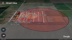
Virtual Range Tour – Google Earth Viewer (with Overlays of Launch Site)
Download the range map KML file and the site map KML File for a full virtual tour in Google Earth. If you don’t have Google Earth installed, go here. Note: to run Google Earth in your browser, you must run Chrome or install the app from this link (e.g. on your iPhone).
Driving Directions from Harris Ranch Inn & Restaurant to LDRS37
24505 W Dorris Ave, Coalinga, CA 93210 – 559-935-0717
- Head out of the North side of the parking lot and turn right onto Highway CA-198 East for 1.5 miles
- Turn left onto South El Dorado Ave and drive 6.0 miles to CA-145.
- Turn right onto CA-145 North and follow the road for 8.6 miles. You will approach a 4-way stop sign and now you are at the “5 Points” intersection.
- Turn left to stay on CA-145 N and drive 7.1 miles to Kamm Ave.
- Turn right onto W Kamm Ave and drive approximately 1.5 miles to N. Del Norte passing Railroad tracks after you make your right. Go 1.25 miles.
- Start slowing down 1.25 miles after your right hand turn onto Kamm from CA-145 and you approach N. Del Norte (which is a dirt road and has a small sign “N. Del Norte”).
- You will see a barricade with a painted “Launch Site” sign at N. Del Norte. You’re close!
- Turn right onto N. Del Norte road. It will have gravel, a slough on the right,side for irrigation and a house on the right hand side approximately 1/4 mile up the road with what looks like a 4-way dirt road intersection. Continue forward and make sure not to drive too far to the right as sometimes the slough overflows and deep river-silt mud is present. Caution: this is a working farm and you could encounter a tractor at this point. Yield right of way to all farm vehicles. You should see the launch site at this point and parked vehicles in the distance.
- Continue on N. Del Norte road until you see Railroad tracks and a Stop sign. Make sure to STOP before passing over the railroad tracks and observe road conditions.
- LDRS37 will be on the left! Turn left at the Railroad tracks and continue slowly down the access road to parking area. Don’t drive over 10mph on the dirt access roads! Avoid Muddy Areas!
Note: There are two Del Norte dirt access roads (N/S) for the fields, if you don’t drive up Kamm after your right hand turn off of CA-145 at least 1 and a quarter miles and start slowing down, you will end up at S. Del Norte and see the launch site in the distance, but have no way to gain access. N. Del Norte road is up approximately 1 mile from S. Del Norte on W. Kamm Ave
Range Details
- See launch safety precautions and PDF maps below for details.
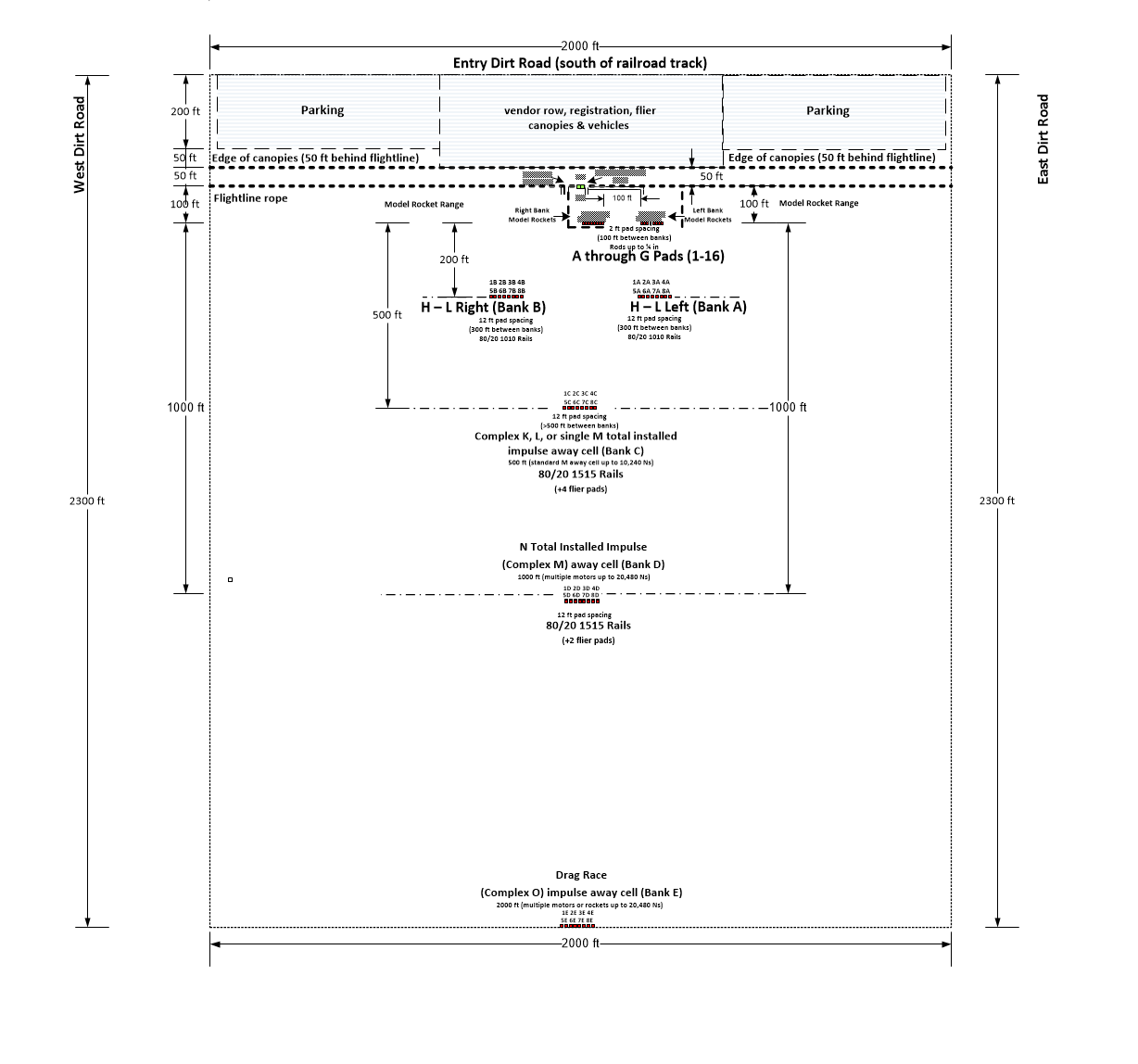
- Range Map (PDF)
- Site Map (including Parking) (PDF)
- Range Map & Distances (PDF)
- Launch Safety Precautions (PDF)
Maps & Driving Directions
- Directions from Harris Ranch (as above, PDF)
- Harris Ranch Site Map (Including conference areas) (PDF)
- TCC & Fresno Waypoints (Google Earth KML)
- TCC & Fresno Waypoints (PDF map)
- TCC & Fresno Location Info (from Maddox Dairy) (PDF)